So, there were some conversations about doing the same pleasant day calculation but to take into account just the period of day when people are generally active. In part, this came from the discussion of the diurnal temperature range and the minimum temperature as they relate to the criteria used and from my own curiosity. Three notes before delving into the results:
- Since most of winter is considered “unpleasant” due to the low temperatures and snowfall, the assumed ‘daytime’ hours are broadly based on summertime daylight hours. This analysis is for times between 7am and 8pm, when people are generally active outside and most local business are open. I suspect there are a number of people who disagree with me, but, my post, my rules. 🙂
- The temperature data record, in this dataset, prior to July 1998 is quite sparse for the hourly data (Figure 1; red and yellow shading). The airport weather station was moved in June, 1998 and is listed as an ASOS station starting then. There is also no precipitation data in this dataset until mid-1998. From 1998 to 2005 (Figure 1, green shading), the data coverage is spotty but consistently covers each day. Only from mid-2005 onward is the data consistently available. Prior to 1999, the data does not average over 90% data coverage per day for the whole year during the 7am to 8pm timeframe. As such; no data prior to 1999 (red and yellow shading) is shown or discussed due to lack of data coverage. A deeper dive into the quality of different meteorological datasets, data processing, and quality control is for a different post.
- Quick reminder of the criteria: A “pleasant day” must be a day with no measurable precipitation, minimum temperature above 45F, maximum temperature below 85F, and have a mean temperature between 55F and 75F.
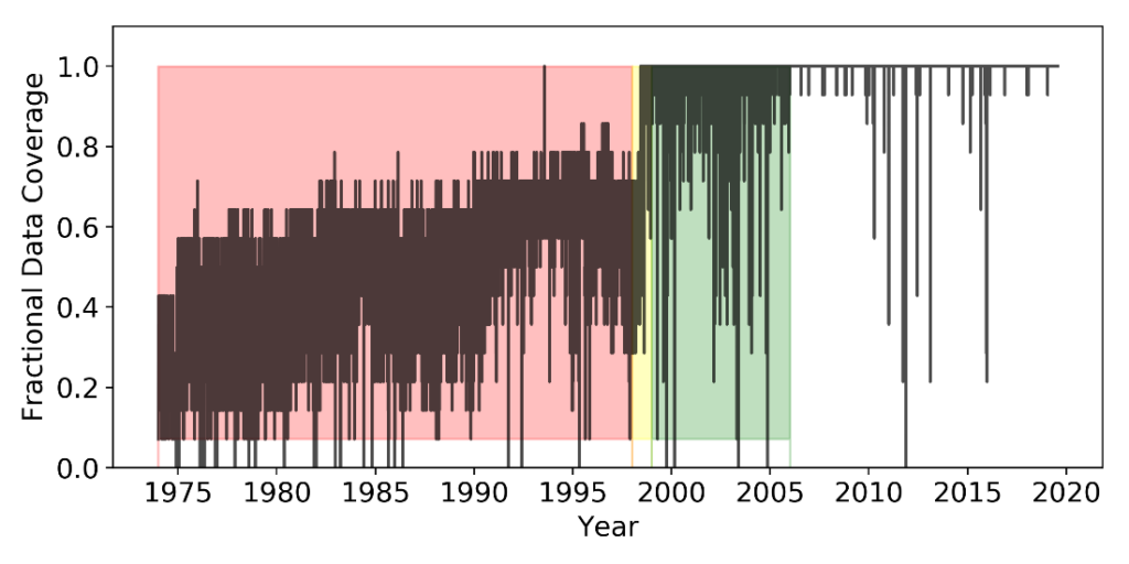
Figure 1. The fractional coverage of temperature data per day from 1974-2018 for the used dataset. The red shading is times between 1974 and 1998, the yellow shading is data during 1998, and the green shading for 1999 to 2006. Data from 2006 onward is not shaded.
With that out of the way; let’s go!
With the restriction of timeframe, the number of pleasant days per year (PD) increases (Figure 2). This should not be surprising if you read the previous post as this analysis constricts the diurnal temperature range by limiting the analysis times attempting to reduce the impact of the minimum temperature on the number of PDs. The general shape over time remained similar for the used 20 year-period as the original (Figure 2). There is a lower but consistent number of PD between 2006 and 2013 from those years being generally cooler than surrounding years. With the differences in data coverage, the number of years, and general shape of the trace, whether the number of PD’s are increasing or decreasing is difficult to diagnose…but some speculation will occur later.
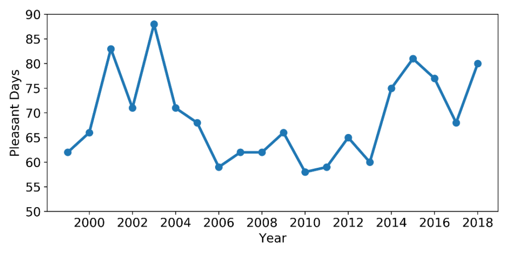
Figure 2. Number of pleasant days per year from 1999 to 2018 using data between 7am and 8pm with the same temperature and precipitation criteria as in the original post and listed in the introduction.
The number of days passing the precipitation check has decreased overtime (Figure 3). In 1999, about 65 days had measurable precipitation and, according to this data, by 2016 that number had increased to closer to 100 days. A deeper analysis of this data is warranted but not in this post. This analysis does not extend to the total amount of precipitation per day and includes days with trace precipitation (defined as less than 0.01 inches) as “precipitation days”. In general, the Pacific Northwest has experienced a varied change in precipitation over the last 100 years, with a relatively consistent but small increase in spring precipitation (Abatzoglou et al., 2013). Precipitation is a highly localized variable, hence the higher level of variability compared to changes in temperature in the region.
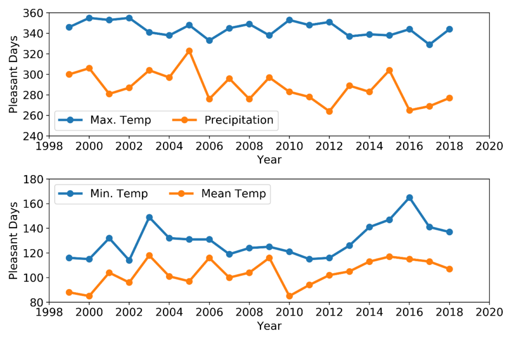
Figure 3. Number of days per year that pass each of the four criteria for a pleasant day. The top panel has maximum temperature and precipitation. The bottom panel has minimum and mean temperature.
Max temperature (Tmax) was the least restrictive component to this analysis (Figure 3, top panel) and stayed relatively consistent across the timeframe with a slight downward trend over time, meaning an increase in the number of days with maximum temperatures above 85F over time. The annual maximum temperature has increased over time for this region but is still generally under 100F (Figure 4). The same pattern was observed in the daily data as well. The max pleasant day limit is 85F and such warm temperatures are still relatively rare around Pullman (20-30 days per year) but are slowly increasing. The maximum temperatures in the Pacific Northwest have been increasing by a couple tenths of a degree Fahrenheit per decade for the last 100 years (Abatzoglou et al., 2013) which accounts for this slow march upward.
The biggest culprits for not having a pleasant day are the mean temperature (Tmean) followed by the minimum temperature (Tmin) (Figure 3, bottom panel). This was mostly from the wintertime periods as even the daytime temperature is generally outside the criteria for a pleasant day from fall to spring (Figure 4). Just the winter temperatures negate the “pleasantness” on the order of 150 days per year with the exact number based on the timing of the seasonal transitions (approximately October-March). This dataset is too short to make any comments on longer-term trends but over time, but assuming a warming climate, the number of pleasant days could fluctuate or increase with how the mean, maximum, and minimum temperature interact. The minimum seasonal temperatures have been increasing in the last 100 years,, with the increase being stronger in the colder months (Abatzoglou et al., 2013).
The mean temperature is defined here as:

If the minimum temperature increases with a constant maximum temperature (oversimplification), then the mean temperature will increase but whether it increases above the threshold for this application depends on the magnitude of change for the minimum temperature. These criteria have the minimum temperature as 45F and the mean in the range of 55-75F. It is possible for the mean temperature to still be outside that range with the minimum temperature above 45F but is rare (Figure 4, top left).
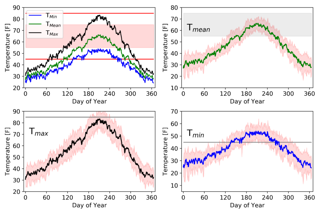
Figure 4. The average maximum, mean, and minimum temperature over the last twenty years (top left) with the thresholds for maximum (85F) and minimum (45F) temperature and shading for the range of mean temperature. The other three panels are the average mean temperature (top right), average maximum temperature (bottom left), and average minimum temperature (bottom right) with the shading representing one standard deviation from the average.
The shading in the top left panel is the mean temperature range and the red lines are the minimum Tmin and maximum Tmax allowed with these criteria. The lines are the mean over the 20-year period and the shading in the other three plots is one standard deviation from the 20-year mean. As can be seen, there are times with the Tmean is outside the acceptable range but Tmin is high enough. Increasing the averaged Tmean just one degree would increase the number of pleasant days and would result from increases in either Tmin, Tmax, or, most likely both. As the climate changes and warms, all three of these lines will shift upward meaning the general climatic temperature any given day will be warmer. In this specific construct; an increase in the minimum temperature could change the number of pleasant days through both the minimum and mean temperature.
I don’t want to get misinterpreted that climate change is good because it means more pleasant weather days; there are very real and very serious consequences from the warming temperatures and changes in the climate that far outweigh a few more pleasant days per year. This exercise is meant to be a more relatable and fun way to look at temperature and precipitation for Pullman over the last 20-50 years than just reporting quasi-abstract temperature and precipitation statistics.
Reference
Abatzoglou, J.T., Rupp, D.E., Mote, P.W., 2013. Seasonal Climate Variability and Change in the Pacific Northwest of the United States. J. Clim. 27, 2125–2142. https://doi.org/10.1175/JCLI-D-13-00218.1
